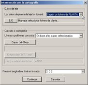
In order to deal with topographic maps it is highly recommended to make use of AutoCAD and, more specifically, one of its most downloaded add-ons: Pprotopo.
Each and every element based on trigonometry can be managed with this plugin for AutoCAD, thus raising all kinds of terrain. For the result to be correct, relevant information such as the total number of sections and the corresponding cant tables must be entered.
Pprotopo supports the various parameters needed for topographic mapping, allowing you to deal with them using as many layers as you want. It is also possible to perform many other actions, such as intersecting objects and joining lines.
show more
- Download Pprotopo 1.0 Download


